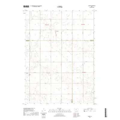
2018 Map of Lanyon
USGS Topo · Published 2018About this map
The town of Paton and the community of Lanyon anchor this rural landscape where the borders of Webster, Greene, and Boone Counties meet. Settled in the late nineteenth century, the region's agricultural character is defined by a network of drainage and waterways, including Ditch Number 187 and the winding Lost Grove Cr. The map captures a well-established section of the Iowa prairie where section-line roads like Kansas Ave and Lanyon Ave grid the terrain, connecting isolated farmsteads to the local grain and rail hubs. Genealogists will find the Paton Township Cem and Renner Cem preserved in the southern reaches, marking the burial grounds of early pioneer families near the banks of Little Beaver Cr and Devils Fork. The survey provides a clear view of the area's transition from wetlands to highly productive farmland through carefully managed channels like E Buttrick Cr.
Find a feature on this map
43 named features on this map. Tap any name to fly to it.
Don’t see what you’re looking for? This feature index may not catch every label — zoom into the map to look around manually.
Map Details
Editions of this 2018 Lanyon Map
This is the sole edition of this map. No revisions or reprints were ever made.
Other maps of this area

1923 · Lehigh
USGS Topo · 1:62,500

1951 · Ogden
USGS Topo · 1:62,500

1954 · Fort Dodge
USGS Topo · 1:250,000

1957 · Fort Dodge
USGS Topo · 1:250,000

1958 · Fort Dodge
USGS Topo · 1:250,000

1962 · Jefferson
USGS Topo · 1:62,500

1965 · Lehigh
USGS Topo · 1:24,000

1965 · Gowrie
USGS Topo · 1:24,000

1965 · Harcourt
USGS Topo · 1:24,000
1982 · Ogden
USGS Topo · 1:24,000