
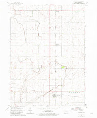
1965 Map of Harcourt
USGS Topo · Published 1966About this map
Harcourt serves as the primary hub for this Webster County agricultural landscape, situated at the junction of the Chicago and North Western and the Fort Dodge Des Moines and Southern railroads. This mid-1960s survey reveals a highly managed prairie environment where natural watercourses like East Buttrick Creek and Crooked Creek are augmented by extensive infrastructure, including Drainage Ditch No 29 and Drainage Ditch No 48. These engineered features define the township boundaries of Clay, Burnside, Lost Grove, and Dayton. Small rural clusters such as Lundgren and Palm Grove sit along the rail lines, while the Lost Grove Cem and a local Park in Harcourt provide a window into the community's social and historical geography. The presence of a Gravel Pit indicates the local extraction industry supporting the region's road and rail networks.
Find a feature on this map
18 named features on this map. Tap any name to fly to it.
Don’t see what you’re looking for? This feature index may not catch every label — zoom into the map to look around manually.
Map Details
Editions of this 1965 Harcourt Map
2 editions found
Other maps of this area

1923 · Lehigh
USGS Topo · 1:62,500

1951 · Ogden
USGS Topo · 1:62,500

1954 · Fort Dodge
USGS Topo · 1:250,000

1957 · Fort Dodge
USGS Topo · 1:250,000

1958 · Fort Dodge
USGS Topo · 1:250,000

1962 · Jefferson
USGS Topo · 1:62,500

1965 · Moorland
USGS Topo · 1:24,000

1965 · Fort Dodge South
USGS Topo · 1:24,000

1965 · Lehigh
USGS Topo · 1:24,000

1965 · Gowrie
USGS Topo · 1:24,000