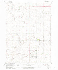
1965 Map of Harcourt
USGS Topo · Published 1982About this map
Harcourt serves as the primary hub of activity in this mid-1960s Iowa landscape, where the Chicago and North Western and the Fort Dodge Des Moines and Southern railroads intersect. This crossroads location, defined by its Corporate Boundary and infrastructure like the Water Tank, reflects the town's role in the regional transport and grain-handling economy. The surrounding sections of Clay, Burnside, Lost Grove, and Dayton townships reveal a highly engineered agricultural environment. An extensive network of drainage channels, including Ditch No 5, Ditch No 29, and Ditch No 48, crisscrosses the terrain to manage water for the surrounding fields. Smaller rural clusters such as Lundgren and Palm Grove stand alongside local landmarks like the Lost Grove Cem and a Gravel Pit, providing essential points of interest for genealogists tracing family locations in Webster County.
Find a feature on this map
19 named features on this map. Tap any name to fly to it.
Don’t see what you’re looking for? This feature index may not catch every label — zoom into the map to look around manually.
Map Details
Editions of this 1965 Harcourt Map
2 editions found

Other maps of this area

1923 · Lehigh
USGS Topo · 1:62,500

1951 · Ogden
USGS Topo · 1:62,500

1954 · Fort Dodge
USGS Topo · 1:250,000

1957 · Fort Dodge
USGS Topo · 1:250,000

1958 · Fort Dodge
USGS Topo · 1:250,000

1962 · Jefferson
USGS Topo · 1:62,500

1965 · Moorland
USGS Topo · 1:24,000

1965 · Fort Dodge South
USGS Topo · 1:24,000

1965 · Lehigh
USGS Topo · 1:24,000

1965 · Gowrie
USGS Topo · 1:24,000