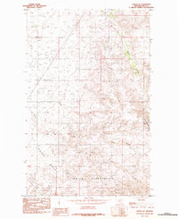
1984 Map of Laredo NE
USGS Topo · Published 1984About this map
The Rocky Boys Indian Reservation dominates the southern landscape of this Hill County survey, showcasing the complex topography where the plains meet more broken country. Based on field checks from the late 1970s, the map illustrates a network of drainage features including the Beaver Creek and the deep incisions of Spring Coulee. The northern sections are defined by agricultural land divisions and distinctive landmarks like Double Wooden Coulee. A single Gravel Pit indicates local small-scale industry, while the South Fork provides a key hydrological reference point. This 1980s record captures the rural character of the region just before the shift into the modern era of land management.
Find a feature on this map
9 named features on this map. Tap any name to fly to it.
Don’t see what you’re looking for? This feature index may not catch every label — zoom into the map to look around manually.
Map Details
Editions of this 1984 Laredo NE Map
This is the sole edition of this map. No revisions or reprints were ever made.
Other maps of this area

1904 · Havre
USGS Topo · 1:62,500

1904 · Assinniboine
USGS Topo · 1:62,500

1912 · Thibedeau Lake
USGS Topo · 1:125,000

1953 · Havre
USGS Topo · 1:250,000

1957 · Havre
USGS Topo · 1:250,000

1958 · Havre
USGS Topo · 1:250,000

1959 · Laredo
USGS Topo · 1:62,500

1959 · Shambo
USGS Topo · 1:62,500

1964 · Havre
USGS Topo · 1:24,000
1970 · Herron Park
USGS Topo · 1:24,000