
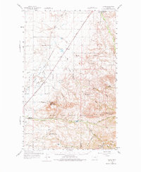
1959 Map of Laredo
USGS Topo · Published 1961About this map
Laredo stands as a rail-centered community along the Great Northern line, serving as a primary point of transit between the plains and the rising terrain of the Rocky Boy Indian Reservation. The map details a landscape where agriculture and cattle ranching intersect with indigenous lands, notably at the Champagne Ranch and the Agriculture Experimental Sta located at the historic Fort Assinniboine Site. To the south, the terrain becomes increasingly complex as it rises toward Wild Horse Ridge and Square Butte. This area is defined by a dense network of coulees, including Schwartz Coulee and Wild Horse Coulee, which channel water toward Big Sandy Creek. Small community hubs like Sangrey and the Sangrey Sch provide evidence of rural settlement patterns within the reservation boundaries during the mid-twentieth century.
Find a feature on this map
29 named features on this map. Tap any name to fly to it.
Don’t see what you’re looking for? This feature index may not catch every label — zoom into the map to look around manually.
Map Details
Editions of this 1959 Laredo Map
2 editions found
Other maps of this area

1904 · Havre
USGS Topo · 1:62,500

1904 · Assinniboine
USGS Topo · 1:62,500

1904 · Boxelder
USGS Topo · 1:62,500

1906 · Kremlin
USGS Topo · 1:62,500

1906 · Boxelder
USGS Topo · 1:62,500

1912 · Thibedeau Lake
USGS Topo · 1:125,000

1919 · Big Sandy
USGS Topo · 1:125,000

1920 · Gildford
USGS Topo · 1:125,000

1943 · Gildford
USGS Topo · 1:125,000

1953 · Havre
USGS Topo · 1:250,000