
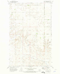
1973 Map of Larslan NW
USGS Topo · Published 1976About this map
Avondale stands as the primary settlement marker within this High Plains landscape, situated along the northern reaches of a drainage system that includes Hell Creek. The geography is defined by the East Fork Snow Coulee, which winds southward across the terrain toward the Fort Peck Indian Reservation Boundary. This 1970s survey captures the precise demarcation where public lands meet reservation territory, a critical boundary for understanding land use and historical tenure in this part of Montana. The sparse distribution of man-made features reflects a ranching and agricultural economy, where small clusters of buildings and survey markers provide the only navigational anchors in an expanse dominated by seasonal coulees and wide prairie draws.
Find a feature on this map
4 named features on this map. Tap any name to fly to it.
Don’t see what you’re looking for? This feature index may not catch every label — zoom into the map to look around manually.
Map Details
Editions of this 1973 Larslan NW Map
This is the sole edition of this map. No revisions or reprints were ever made.
Other maps of this area

1954 · Glasgow
USGS Topo · 1:250,000

1957 · Glasgow
USGS Topo · 1:250,000

1958 · Glasgow
USGS Topo · 1:250,000

1973 · Baylor SE
USGS Topo · 1:24,000

1973 · Larslan
USGS Topo · 1:24,000

1973 · Glentana West
USGS Topo · 1:24,000

1973 · Baylor NE
USGS Topo · 1:24,000

1973 · Johnnys Hill
USGS Topo · 1:24,000

1973 · Richland
USGS Topo · 1:24,000
1973 · Blink Springs
USGS Topo · 1:24,000