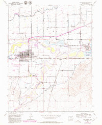
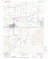
1953 Map of Las Animas
USGS Topo · Published 1979About this map
The Arkansas River and Purgatoire River converge in this mid-century survey of the high plains, revealing an irrigation-driven landscape at the junction of two major valleys. The city of Las Animas dominates the river fork, showing a structured grid south of the Atchison Topeka and Santa Fe railroad line. Southeast of the main town lies the important pioneer site of Boggsville, while to the northeast, the massive grounds of the Fort Lyon Veterans Hospital stand near the edge of the John Martin Reservoir. The map provides a rare combination of modern 1950s infrastructure, like the City and County Airport, alongside remnants of western history including the Old Santa Fe Trail and the small agricultural siding at Waveland. Extensive canal systems such as the Consolidated Ditch and Highland Canal illustrate the intensive effort to water the Picketwire Valley.
Find a feature on this map
31 named features on this map. Tap any name to fly to it.
Don’t see what you’re looking for? This feature index may not catch every label — zoom into the map to look around manually.
Map Details
Editions of this 1953 Las Animas Map
6 editions found
Other maps of this area

1891 · Higbee
USGS Topo · 1:125,000

1891 · Las Animas
USGS Topo · 1:125,000

1893 · Higbee
USGS Topo · 1:125,000

1893 · Las Animas
USGS Topo · 1:125,000

1953 · Las Animas
USGS Topo · 1:24,000

1953 · Cornelia
USGS Topo · 1:24,000

1953 · Kreybill
USGS Topo · 1:24,000

1954 · Lamar
USGS Topo · 1:250,000

1955 · Tree Top Ranch
USGS Topo · 1:24,000

1955 · Mc Intosh Ranch
USGS Topo · 1:24,000