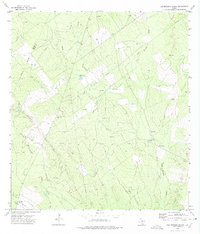
1972 Map of Las Escobas Ranch
USGS Topo · Published 1975About this map
Las Escobas Ranch sits at the heart of this South Texas cattle and oil landscape, straddling the boundary between Zapata and Starr Counties. The area is defined by a network of drainage systems including Las Escobas and Del Puerto Creek, where the land is dotted with oil wells and essential water infrastructure like the Paleta Windmill. For local historians and genealogists, the presence of isolated burial grounds such as Buena Vista, Uña de Gato, and Agua Dulce cemeteries provides a window into the family heritage of this brush country. The map illustrates a working landscape where industrial pipelines intersect with traditional ranching outposts, reflecting the dual economy of the Rio Grande Valley hinterlands in the early 1970s.
Find a feature on this map
15 named features on this map. Tap any name to fly to it.
Don’t see what you’re looking for? This feature index may not catch every label — zoom into the map to look around manually.
Map Details
Editions of this 1972 Las Escobas Ranch Map
2 editions found
Other maps of this area

1938 · Falcon
USGS Topo · 1:62,500

1938 · El Sauz
USGS Topo · 1:62,500

1938 · Cuevitas
USGS Topo · 1:62,500

1949 · Mc Allen
USGS Topo · 1:250,000

1954 · McAllen
USGS Topo · 1:250,000

1956 · Arroyo Clareno
USGS Topo · 1:62,500

1957 · Mc Allen
USGS Topo · 1:250,000

1962 · McAllen
USGS Topo · 1:250,000

1965 · Salineno
USGS Topo · 1:24,000

1965 · Lopeno
USGS Topo · 1:24,000