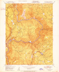
1950 Map of Las Plumas
USGS Topo · Published 1950About this map
Big Bend Mountain dominates the center of this 1950 Butte County landscape, surrounded by the deep incisions of the North Fork Feather River and its various branches. This era shows a rugged region defined by industrial extraction and hydroelectric potential, with the Western Pacific railroad snaking along the riverbanks through tunnels and past remote outposts like Isaiah and Berry Creek Station. The presence of several named lode claims, such as the Surcease Mine and Evening Star Mine, indicates a persistent mining interest in the hills north of the river. Small settlements and specialized landmarks are scattered throughout the Plumas National Forest, including the community of Las Plumas and the local Berry Creek Sch. The map also captures infrastructure like the Diversion Dam and Powerhouse, reflecting the engineering works of the Bureau Of Reclamation in this mountainous terrain during the mid-twentieth century.
Find a feature on this map
64 named features on this map. Tap any name to fly to it.
Don’t see what you’re looking for? This feature index may not catch every label — zoom into the map to look around manually.
Map Details
Editions of this 1950 Las Plumas Map
2 editions found
Other maps of this area

1888 · Bidwell Bar
USGS Topo · 1:125,000

1891 · Bidwell Bar
USGS Topo · 1:125,000

1891 · Chico
USGS Topo · 1:125,000

1893 · Chico
USGS Topo · 1:125,000

1893 · Bidwell Bar
USGS Topo · 1:125,000

1895 · Bidwell Bar
USGS Topo · 1:125,000

1895 · Chico
USGS Topo · 1:125,000

1897 · Bidwell Bar
USGS Topo · 1:125,000

1912 · Oroville
USGS Topo · 1:31,680

1942 · Oroville
USGS Topo · 1:62,500