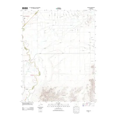
2013 Map of Lasauses
USGS Topo · Published 2013About this map
The settlement of Lasauses occupies a significant bend in the Rio Grande, situated near the confluence where the Conejos River meets the larger waterway. This high-altitude valley landscape is defined by its complex irrigation and water management, visible in the Conejos River Diversion and a network of county roads like Stoner Rd and Avondale that follow the section lines of the surrounding ranch land. To the north, Hansen Bluff rises above the river plains, carrying the Bluff Nature Trail T301 along its edge, while the Becker Cem provides a point of genealogical interest for those researching early families in this part of Conejos County. The southern portion of the map is dominated by the volcanic topography of the San Luis Hills, which contrast sharply with the level riparian flats where Trinchera Cr winds toward the river.
Find a feature on this map
69 named features on this map. Tap any name to fly to it.
Don’t see what you’re looking for? This feature index may not catch every label — zoom into the map to look around manually.
Map Details
Editions of this 2013 Lasauses Map
This is the sole edition of this map. No revisions or reprints were ever made.
Other maps of this area

1954 · Trinidad
USGS Topo · 1:250,000

1955 · Trinidad
USGS Topo · 1:250,000

1958 · Trinidad
USGS Topo · 1:250,000

1959 · Trinidad
USGS Topo · 1:250,000

1965 · Blanca
USGS Topo · 1:24,000

1965 · Baldy
USGS Topo · 1:24,000

1965 · Lasauses
USGS Topo · 1:24,000

1965 · Blanca SE
USGS Topo · 1:24,000
1966 · Alamosa East
USGS Topo · 1:24,000

1967 · Manassa NE
USGS Topo · 1:24,000