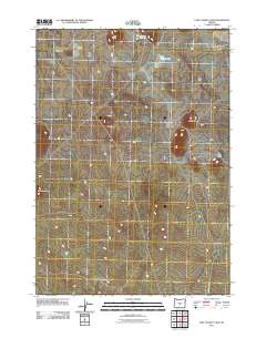
2011 Map of Last Chance Lake
USGS Topo · Published 2011About this map
Last Chance Lake and the surrounding high desert topography define this portion of central Oregon. The landscape is marked by a series of prominent volcanic features including Dog Butte, Trail Butte, and Sage Hen Butte, which rise above the level plains. Water in this arid environment is concentrated in seasonal or shallow basins such as Paiute Lake and the winding Chewaucan Slough. The area's infrastructure is sparse, dominated by a network of unimproved roads and the route of County Hwy 128, reflecting a remote region primarily used for ranching or open-range management. To the east, the elevation shifts toward Saddle Butte, showcasing the typical basin and range characteristics of the Oregon outback at the start of the twenty-first century.
Find a feature on this map
8 named features on this map. Tap any name to fly to it.
Don’t see what you’re looking for? This feature index may not catch every label — zoom into the map to look around manually.
Map Details
Editions of this 2011 Last Chance Lake Map
This is the sole edition of this map. No revisions or reprints were ever made.
Other maps of this area

1955 · Crescent
USGS Topo · 1:250,000

1957 · Crescent
USGS Topo · 1:250,000

1958 · Crescent
USGS Topo · 1:250,000

1970 · Crescent
USGS Topo · 1:250,000

1981 · Mean Rock Well
USGS Topo · 1:24,000

1982 · Peters Creek Sink
USGS Topo · 1:24,000

1982 · Jacks Place
USGS Topo · 1:24,000
1983 · Soldiers Cap
USGS Topo · 1:24,000

1983 · Imperial Valley South
USGS Topo · 1:24,000
1983 · Last Chance Lake
USGS Topo · 1:24,000