
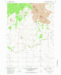
1982 Map of Jacks Place
USGS Topo · Published 1983About this map
The remote volcanic landscape of Lake County is defined by the expansive East Lava Field and the adjacent Four Craters Lava Field, creating a complex geological record of past eruptions. In the early 1980s, the isolated settlement of Jacks Place stood as a lone human waypoint in an environment dominated by cinder cones and lava flows. Topographic features such as Lava Mountain and Twin Buttes rise above the jagged terrain, while subsurface exploration is noted by the Ice Cave Pothole and Ice Cave. Water management is the primary sign of land use here, with various basins and wells such as Coyote Hole Reservoir, Sixteen Well, and Seventeen Well scattered across the sagebrush and lava to support livestock in an otherwise arid region.
Find a feature on this map
18 named features on this map. Tap any name to fly to it.
Don’t see what you’re looking for? This feature index may not catch every label — zoom into the map to look around manually.
Map Details
Editions of this 1982 Jacks Place Map
This is the sole edition of this map. No revisions or reprints were ever made.
Other maps of this area

1955 · Crescent
USGS Topo · 1:250,000

1957 · Crescent
USGS Topo · 1:250,000

1958 · Crescent
USGS Topo · 1:250,000

1970 · Crescent
USGS Topo · 1:250,000

1981 · Fox Butte
USGS Topo · 1:24,000

1981 · Hogback Butte
USGS Topo · 1:24,000

1981 · Lane Lake
USGS Topo · 1:24,000

1982 · Peters Creek Sink
USGS Topo · 1:24,000

1982 · Christmas Lake
USGS Topo · 1:24,000
1983 · Crack-in-the-Ground
USGS Topo · 1:24,000