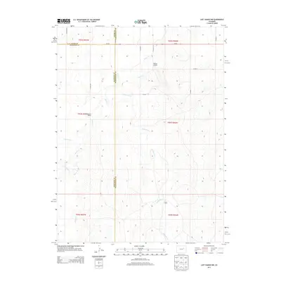
2013 Map of Last Chance NW
USGS Topo · Published 2013About this map
Fraizer Farms stands as a focal point in this 2013 survey of the High Plains, where Arapahoe, Adams, and Washington counties meet. The landscape is defined by an intricate network of drainage systems, including the serpentine paths of Beaver Cr and Middlemist Cr. These waterways cut through the terrain to create distinct landforms such as Bobcat Canyon and the broad Cottonwood Valley. While modern infrastructure is represented by the transit corridor of Us-36 E and a grid of local routes like Windview Rd, the map reveals a predominantly agricultural and ranching environment. The sparse distribution of named farmsteads and the preservation of natural features like Cottonwood Cr and Rattlesnake Cr reflect a rural continuity in eastern Colorado, showing how the local topography dictates the patterns of habitation and land use.
Find a feature on this map
25 named features on this map. Tap any name to fly to it.
Don’t see what you’re looking for? This feature index may not catch every label — zoom into the map to look around manually.
Map Details
Editions of this 2013 Last Chance NW Map
This is the sole edition of this map. No revisions or reprints were ever made.
Other maps of this area

1954 · Limon
USGS Topo · 1:250,000

1957 · Limon
USGS Topo · 1:250,000

1958 · Limon
USGS Topo · 1:250,000

1973 · Last Chance SW
USGS Topo · 1:24,000
1973 · Cottonwood Valley South
USGS Topo · 1:24,000

1973 · Last Chance NW
USGS Topo · 1:24,000

1973 · Lusto Springs
USGS Topo · 1:24,000

1973 · Last Chance
USGS Topo · 1:24,000
1973 · Cottonwood Valley North
USGS Topo · 1:24,000

1973 · Wetzel Creek
USGS Topo · 1:24,000