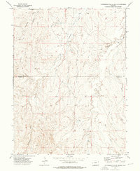
1973 Map of Cottonwood Valley South
USGS Topo · Published 1976About this map
Arapahoe Co and Elbert Co share a boundary line across this high plains terrain, captured during a 1973 field check by the Geological Survey. The landscape is defined by the winding drainages of Cottonwood Creek, Rattlesnake Creek, and Beaver Creek, which carve out the distinct valleys of the region. Human imprint on this vast rangeland is sparse, centered primarily on the Cross J Ranch and a network of selected fence lines. The topography reveals a series of ridgelines and draws that dictate the placement of ranch roads and livestock boundaries. This survey provides a clear view of land use and water distribution in this portion of Colorado before later development, showing the isolated homesteads and natural drainage patterns that characterized the area in the early 1970s.
Find a feature on this map
5 named features on this map. Tap any name to fly to it.
Don’t see what you’re looking for? This feature index may not catch every label — zoom into the map to look around manually.
Map Details
Editions of this 1973 Cottonwood Valley South Map
This is the sole edition of this map. No revisions or reprints were ever made.
Other maps of this area

1891 · Limon
USGS Topo · 1:125,000

1892 · Limon
USGS Topo · 1:125,000

1954 · Limon
USGS Topo · 1:250,000

1957 · Limon
USGS Topo · 1:250,000

1958 · Limon
USGS Topo · 1:250,000
1969 · Noonen Reservoir SW
USGS Topo · 1:24,000
1969 · Noonen Reservoir
USGS Topo · 1:24,000

1970 · Agate
USGS Topo · 1:24,000
1970 · Barking Dog Spring
USGS Topo · 1:24,000

1970 · T Draw
USGS Topo · 1:24,000