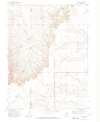
1970 Map of T Draw
USGS Topo · Published 1974About this map
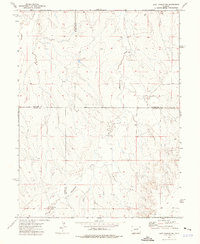
Middlemist Creek and Vega Creek carve their way through this section of the High Plains, where the border of Elbert Co and Lincoln Co meets. The landscape is defined by the namesake T Draw, an area of complex topography marked by seasonal water sources including numerous Spring sites and a livestock Tank. This 1970 field-checked survey reveals an agricultural and ranching environment during a period of modernization, evidenced by the presence of a Radio Tower and Storage Bins. The sparse network of routes, including a remote Jeep Trail, reflects the isolation of these eastern Colorado plains. For those studying the rural development of the region, the map provides precise locations for utilitarian landmarks like a solitary Storage Bin and a localized Tower, mapping the intersection of natural drainage and human infrastructure.
Find a feature on this map
11 named features on this map. Tap any name to fly to it.
Don’t see what you’re looking for? This feature index may not catch every label — zoom into the map to look around manually.
Map Details
Editions of this 1970 T Draw Map
This is the sole edition of this map. No revisions or reprints were ever made.
Other maps of this area

1891 · Limon
USGS Topo · 1:125,000

1892 · Limon
USGS Topo · 1:125,000

1954 · Limon
USGS Topo · 1:250,000

1957 · Limon
USGS Topo · 1:250,000

1958 · Limon
USGS Topo · 1:250,000
1970 · Limon
USGS Topo · 1:24,000
1970 · Barking Dog Spring
USGS Topo · 1:24,000
1970 · River Bend
USGS Topo · 1:24,000
1973 · Last Chance SW
USGS Topo · 1:24,000
1973 · Cottonwood Valley South
USGS Topo · 1:24,000