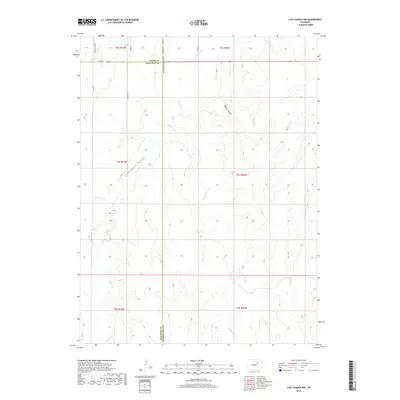
2019 Map of Last Chance NW
USGS Topo · Published 2019About this map
Cottonwood Valley and its surrounding high plains landscape define this section of Colorado where Adams, Arapahoe, and Washington counties converge. The drainage system is the primary geographic driver here, with Beaver Cr and Middlemist Cr carving through the terrain alongside Bobcat Canyon. The land is organized by the Public Land Survey System, as evidenced by the straight-line county roads and township boundaries such as t4s r57w that intersect the natural topography. The map reveals an area defined by agricultural or ranching transit, where long-established section-line routes like Meridian Rd Co Rd 72 and Winview Mile Rd provide the only infrastructure across the wide drainage basins of Cottonwood Cr and Rattlesnake Cr.
Find a feature on this map
22 named features on this map. Tap any name to fly to it.
Don’t see what you’re looking for? This feature index may not catch every label — zoom into the map to look around manually.
Map Details
Editions of this 2019 Last Chance NW Map
This is the sole edition of this map. No revisions or reprints were ever made.
Other maps of this area

1954 · Limon
USGS Topo · 1:250,000

1957 · Limon
USGS Topo · 1:250,000

1958 · Limon
USGS Topo · 1:250,000

1973 · Last Chance SW
USGS Topo · 1:24,000
1973 · Cottonwood Valley South
USGS Topo · 1:24,000

1973 · Last Chance NW
USGS Topo · 1:24,000

1973 · Lusto Springs
USGS Topo · 1:24,000

1973 · Last Chance
USGS Topo · 1:24,000
1973 · Cottonwood Valley North
USGS Topo · 1:24,000

1973 · Wetzel Creek
USGS Topo · 1:24,000