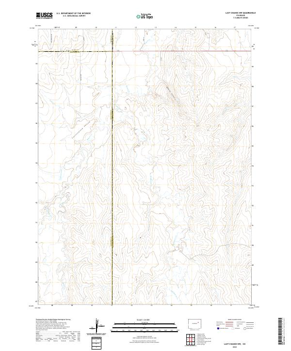
2022 Map of Last Chance NW
USGS Topo · Published 2022About this map
Cottonwood Valley and Bobcat Canyon define the landscape of this high plains region, where the borders of Adams, Washington, and Arapahoe Counties meet. The terrain is deeply etched by a network of drainage systems including Beaver Cr, Middlemist Cr, and Cottonwood Cr, which have carved significant depressions into the plateau. Unlike more densely settled regions, this area maintains a strict section-line grid of rural roads, such as Winview Mile Rd and N Davison Rd, reflecting the enduring agricultural and ranching layout of eastern Colorado. The mapping detail shows the subtle topography of the Rattlesnake Cr watershed and the long-established county boundaries that partition these open spaces. This survey provides a precise look at the land and water patterns before any modern development might alter these traditional property divisions.
Find a feature on this map
22 named features on this map. Tap any name to fly to it.
Don’t see what you’re looking for? This feature index may not catch every label — zoom into the map to look around manually.
Map Details
Editions of this 2022 Last Chance NW Map
This is the sole edition of this map. No revisions or reprints were ever made.
Other maps of this area

1954 · Limon
USGS Topo · 1:250,000

1957 · Limon
USGS Topo · 1:250,000

1958 · Limon
USGS Topo · 1:250,000

1973 · Last Chance SW
USGS Topo · 1:24,000
1973 · Cottonwood Valley South
USGS Topo · 1:24,000

1973 · Last Chance NW
USGS Topo · 1:24,000

1973 · Lusto Springs
USGS Topo · 1:24,000

1973 · Last Chance
USGS Topo · 1:24,000
1973 · Cottonwood Valley North
USGS Topo · 1:24,000

1973 · Wetzel Creek
USGS Topo · 1:24,000