
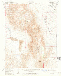
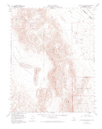
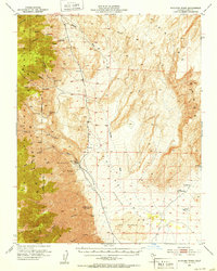
1958 Map of Last Chance Range
USGS Topo · Published 1965About this map
The high-desert expanse of the Last Chance Range dominates this late-1950s survey, revealing a landscape defined by extreme topography and scarce water sources. This reach of the Inyo County and Esmeralda County border includes the eastern edge of Eureka Valley with its prominent Sand Dunes and the northern reaches of Death Valley National Monument. Primitive transportation routes, such as South Eureka Road and various unnamed jeep trails, provide the only access through steep terrain like Hanging Rock Canyon. Local geography is marked by isolated landmarks and summits, including a prominent Crater and survey stations like Sandy. Evidence of human activity is limited to mineral Prospects and vital water points like Little Sand Spring and Sand Spr, which were essential for survival in this arid corridor where Oriental Wash and Death Valley Wash cut through the alluvial fans.
Find a feature on this map
23 named features on this map. Tap any name to fly to it.
Don’t see what you’re looking for? This feature index may not catch every label — zoom into the map to look around manually.
Map Details
Editions of this 1958 Last Chance Range Map
3 editions found
Other maps of this area

1908 · Lida
USGS Topo · 1:250,000

1908 · Ballarat
USGS Topo · 1:250,000

1913 · Lida
USGS Topo · 1:250,000

1913 · Ballarat
USGS Topo · 1:250,000

1948 · Death Valley
USGS Topo · 1:250,000
1951 · Waucoba Wash
USGS Topo · 1:62,500

1954 · Death Valley
USGS Topo · 1:250,000

1954 · Goldfield
USGS Topo · 1:250,000

1955 · Goldfield
USGS Topo · 1:250,000

1956 · Death Valley
USGS Topo · 1:250,000