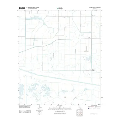
2012 Map of Latanier Bayou
USGS Topo · Published 2012About this map
Florence Landing sits at the eastern edge of a highly engineered landscape defined by an extensive drainage and irrigation network in Vermilion Parish. This 2012 survey illustrates how the coastal prairie has been partitioned by features like the Gueydan Canal and numbered arteries such as Canal Number Ten. The industrial footprint of the region is evident through the Southwest Gueydan Gas Field and Cameron Canal Gas Field, while localized landmarks like Deer Island and Gueydon Cem provide anchor points for family historians. The grid of parish roads, including Parish Road 110 and Ellis Bridge Rd, traces the boundaries of agricultural and extraction tracts typical of the Louisiana wetlands. This map provides a clear record of the intersection between the energy industry and the managed water systems of the lower bayou country.
Find a feature on this map
36 named features on this map. Tap any name to fly to it.
Don’t see what you’re looking for? This feature index may not catch every label — zoom into the map to look around manually.
Map Details
Editions of this 2012 Latanier Bayou Map
This is the sole edition of this map. No revisions or reprints were ever made.
Other maps of this area

1946 · Morse
USGS Topo · 1:31,680

1946 · Lake Arthur
USGS Topo · 1:31,680

1946 · Schooner Bayou NW
USGS Topo · 1:31,680

1946 · Schooner Bayou SW
USGS Topo · 1:31,680

1949 · Gueydan
USGS Topo · 1:31,680

1952 · Lake Charles
USGS Topo · 1:250,000

1953 · Jacks Point Island
USGS Topo · 1:24,000

1954 · Grand Lake East NW
USGS Topo · 1:31,680

1954 · Grand Lake East SE
USGS Topo · 1:31,680
1954 · Grand Lake East SW
USGS Topo · 1:31,680