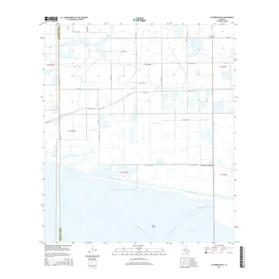
2015 Map of Latanier Bayou
USGS Topo · Published 2015About this map
The low-lying coastal prairie and wetlands of Vermilion and Cameron Parish are defined by a complex network of industrial and agricultural waterways. Dominating the southern portion of the map is the Intracoastal Waterway, a vital artery for Gulf Coast commerce that cuts through the marshes north of Deer Island. The landscape is a grid of irrigation and transport canals, such as the Gueydan Canal and Stanolind Canal, which support the region's rice farming and oil industries.
Find a feature on this map
46 named features on this map. Tap any name to fly to it.
Don’t see what you’re looking for? This feature index may not catch every label — zoom into the map to look around manually.
Map Details
Editions of this 2015 Latanier Bayou Map
This is the sole edition of this map. No revisions or reprints were ever made.
Other maps of this area

1946 · Morse
USGS Topo · 1:31,680

1946 · Lake Arthur
USGS Topo · 1:31,680

1946 · Schooner Bayou NW
USGS Topo · 1:31,680

1946 · Schooner Bayou SW
USGS Topo · 1:31,680

1949 · Gueydan
USGS Topo · 1:31,680

1952 · Lake Charles
USGS Topo · 1:250,000

1953 · Jacks Point Island
USGS Topo · 1:24,000

1954 · Grand Lake East NW
USGS Topo · 1:31,680

1954 · Grand Lake East SE
USGS Topo · 1:31,680
1954 · Grand Lake East SW
USGS Topo · 1:31,680