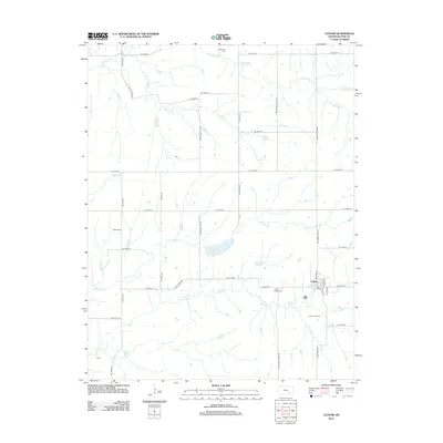
2012 Map of Latham
USGS Topo · Published 2012About this map
Latham serves as the primary hub of this southeast Butler County landscape, situated where the grid of rural roads meets the waters of Rock Cr. The area is defined by its agricultural and industrial character, notably the presence of the Latham Oil Field south of the town center. The landscape is carved by a network of drainage systems including Plum Cr and Hickory Cr, which flow through the undulating terrain. For those tracing local heritage, several burial grounds are scattered across the quadrangle, including Latham Cem near the town site, Brownlow Cem to the north, and Bryant Cem to the west. The small settlement of Ophir appears in the southwest corner, while Lake Clymer provides a significant water feature in the central portion of the map, illustrating the intersection of natural hydrology and local development.
Find a feature on this map
40 named features on this map. Tap any name to fly to it.
Don’t see what you’re looking for? This feature index may not catch every label — zoom into the map to look around manually.
Map Details
Editions of this 2012 Latham Map
This is the sole edition of this map. No revisions or reprints were ever made.
Other maps of this area

1888 · Eldorado
USGS Topo · 1:125,000

1889 · Burden
USGS Topo · 1:125,000

1955 · Wichita
USGS Topo · 1:250,000

1958 · Wichita
USGS Topo · 1:250,000

1963 · Leon
USGS Topo · 1:24,000

1964 · Augusta SE
USGS Topo · 1:24,000

1964 · Beaumont
USGS Topo · 1:24,000

1964 · Latham
USGS Topo · 1:24,000

1964 · Cambridge NW
USGS Topo · 1:24,000
1964 · Keighley
USGS Topo · 1:24,000