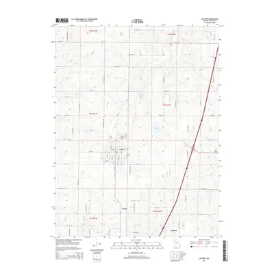
2014 Map of Lathrop
USGS Topo · Published 2014About this map
Lathrop serves as the central hub of this Clinton County landscape, where a dense grid of streets meets the surrounding agricultural terrain. The map documents a classic Missouri township structure, with the town's core containing the Lathrop Cemetery and situated near several water bodies including Lathrop Lake and Lake McGinness. To the south, the small settlements of Guyton and Converse appear as localized points of interest along the rural road network. The physical geography is defined by a network of drainage systems, most notably the Muddy Fork and the Crooked River, which carve through the undulating land. Genealogists may find particular value in the placement of Bethel Cemetery on the eastern edge of the quadrangle, while local historians can trace the transition from residential town lots to larger rural sections along NE Breckenridge Rd and SE Powell Rd.
Find a feature on this map
72 named features on this map. Tap any name to fly to it.
Don’t see what you’re looking for? This feature index may not catch every label — zoom into the map to look around manually.
Map Details
Editions of this 2014 Lathrop Map
This is the sole edition of this map. No revisions or reprints were ever made.
Other maps of this area

1894 · Independence
USGS Topo · 1:125,000

1924 · Polo
USGS Topo · 1:62,500

1925 · Plattsburg
USGS Topo · 1:62,500

1936 · Kearney
USGS Topo · 1:48,000

1942 · Kearney
USGS Topo · 1:62,500

1945 · Kearney
USGS Topo · 1:62,500

1950 · Kansas City
USGS Topo · 1:250,000

1954 · Kansas City
USGS Topo · 1:250,000

1956 · Kansas City
USGS Topo · 1:250,000
1957 · Lawson
USGS Topo · 1:24,000