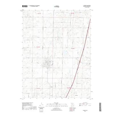
2017 Map of Lathrop
USGS Topo · Published 2017About this map
Lathrop serves as the primary hub in this Missouri landscape, defined by a grid of rural roads and the headwaters of several regional waterways. The town layout is clearly delineated, showing its proximity to Lathrop Lake and the branching paths of Shoal Cr and Little Shoal Cr. This 2017 survey captures the rural character of Clinton County, where agricultural land is segmented by an extensive network of named county roads like NE 292nd St and NE Breckenridge Rd.
Find a feature on this map
81 named features on this map. Tap any name to fly to it.
Don’t see what you’re looking for? This feature index may not catch every label — zoom into the map to look around manually.
Map Details
Editions of this 2017 Lathrop Map
This is the sole edition of this map. No revisions or reprints were ever made.
Other maps of this area

1894 · Independence
USGS Topo · 1:125,000

1924 · Polo
USGS Topo · 1:62,500

1925 · Plattsburg
USGS Topo · 1:62,500

1936 · Kearney
USGS Topo · 1:48,000

1942 · Kearney
USGS Topo · 1:62,500

1945 · Kearney
USGS Topo · 1:62,500

1950 · Kansas City
USGS Topo · 1:250,000

1954 · Kansas City
USGS Topo · 1:250,000

1956 · Kansas City
USGS Topo · 1:250,000
1957 · Lawson
USGS Topo · 1:24,000