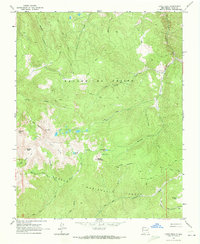
1963 Map of Latir Peak
USGS Topo · Published 1973About this map
The high ridges of the Sangre de Cristo mountains define this 1963 survey of the New Mexico backcountry, dominated by the formidable elevation of Latir Peak and the expansive Latir Mesa. The landscape is a network of alpine basins containing the Latir Lakes, Heart Lake, and Bear Lake, all situated within the protected boundaries of the Carson National Forest. Human presence in this high-altitude terrain is limited to the isolated Baldy Cabin and a scattered series of pack trails and jeep trails that navigate the steep drainages of Latir Creek and Midnight Creek.
Find a feature on this map
31 named features on this map. Tap any name to fly to it.
Don’t see what you’re looking for? This feature index may not catch every label — zoom into the map to look around manually.
Map Details
Editions of this 1963 Latir Peak Map
Other maps of this area

1954 · Raton
USGS Topo · 1:250,000

1958 · Raton
USGS Topo · 1:250,000

1963 · Costilla
USGS Topo · 1:24,000

1963 · Amalia
USGS Topo · 1:24,000

1963 · Red River Pass
USGS Topo · 1:24,000

1963 · Cerro
USGS Topo · 1:24,000

1963 · Questa
USGS Topo · 1:24,000

1963 · Latir Peak
USGS Topo · 1:24,000

1963 · Comanche Point
USGS Topo · 1:24,000

1963 · Red River
USGS Topo · 1:24,000