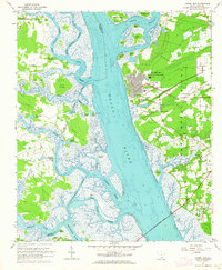
1962 Map of Laurel Bay
USGS Topo · Published 1964About this map
The Laurel Bay (Naval Housing Area) sits prominently on the eastern bank of the Broad River, showcasing a detailed grid of mid-century military residential planning. This coastal landscape is defined by its deep saltwater inlets and marshy islands, including Port Royal Island and Big Island. Significant transportation arteries of the era, the Seaboard Air Line RR and Atlantic Coast Line RR, cross the northern reaches near Murad, while the Edward Burton Rodgers Bridge spans the southern river channel.
Find a feature on this map
64 named features on this map. Tap any name to fly to it.
Don’t see what you’re looking for? This feature index may not catch every label — zoom into the map to look around manually.
Map Details
Editions of this 1962 Laurel Bay Map
2 editions found
Other maps of this area

1918 · Green Pond
USGS Topo · 1:62,500

1918 · Yemassee
USGS Topo · 1:62,500

1920 · Okatie
USGS Topo · 1:62,500

1942 · Okatie
USGS Topo · 1:62,500

1943 · Yemassee
USGS Topo · 1:62,500

1943 · Green Pond
USGS Topo · 1:62,500

1944 · Fort Fremont
USGS Topo · 1:62,500

1947 · Savannah
USGS Topo · 1:250,000

1948 · Savannah
USGS Topo · 1:250,000
1956 · Parris Island
USGS Topo · 1:24,000