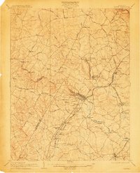
1907 Map of Laurel
USGS Topo · Published 1912About this map
Laurel serves as the central hub in this early twentieth-century survey, situated at the intersection of a developing rail network and the winding courses of the Middle Patuxent River and Little Patuxent River. The landscape reveals a transition from traditional agricultural practices to early industrial and institutional development, evidenced by the Baltimore and Ohio RR (Washington Branch) and the presence of the Normal Institute.
Find a feature on this map
88 named features on this map. Tap any name to fly to it.
Don’t see what you’re looking for? This feature index may not catch every label — zoom into the map to look around manually.
Map Details
Editions of this 1907 Laurel Map
3 editions found

Other maps of this area

1890 · Mt. Vernon
USGS Topo · 1:125,000

1891 · Mt. Vernon
USGS Topo · 1:125,000

1892 · Laurel
USGS Topo · 1:62,500

1892 · Ellicott
USGS Topo · 1:62,500

1892 · Owensville
USGS Topo · 1:62,500

1893 · Frederick
USGS Topo · 1:125,000

1894 · Ellicott
USGS Topo · 1:62,500

1894 · Laurel
USGS Topo · 1:62,500

1894 · Baltimore
USGS Topo · 1:62,500

1894 · Frederick
USGS Topo · 1:125,000