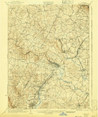
1926 Map of Laurel
USGS Topo · Published 1941About this map
The Patuxent River system, including its Middle and Little branches, defines the central geography of this central Maryland region in the early twentieth century. The map illustrates a landscape transitioning from rural agricultural uses to more complex institutional and military development. Key transport corridors like the Baltimore and Ohio RR and the Washington and Baltimore Electric Ry connect growing hubs such as Savage and Jessup, while the presence of the Fort George G. Meade Military Reservation signals a shift in land use on the eastern edge. Local life is anchored by family-named landmarks and institutions like Christian Brothers College, the Willis School, and the House of Reformation near Rockwell. Numerous bridges, including Snell Bridge and Brock Bridge, facilitate movement across the dissected river valleys that once powered sites like Hicks Mill.
Find a feature on this map
99 named features on this map. Tap any name to fly to it.
Don’t see what you’re looking for? This feature index may not catch every label — zoom into the map to look around manually.
Map Details
Editions of this 1926 Laurel Map
4 editions found
Other maps of this area

1890 · Mt. Vernon
USGS Topo · 1:125,000

1891 · Mt. Vernon
USGS Topo · 1:125,000

1892 · Laurel
USGS Topo · 1:62,500

1892 · Ellicott
USGS Topo · 1:62,500

1892 · Owensville
USGS Topo · 1:62,500

1893 · Frederick
USGS Topo · 1:125,000

1894 · Ellicott
USGS Topo · 1:62,500

1894 · Laurel
USGS Topo · 1:62,500

1894 · Baltimore
USGS Topo · 1:62,500

1894 · Frederick
USGS Topo · 1:125,000