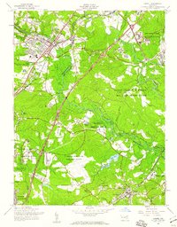
1957 Map of Laurel
USGS Topo · Published 1960About this map
The Patuxent River corridor between Washington and Baltimore serves as a transition between growing suburban settlements and large federal landholdings during the late 1950s. The city of Laurel is a primary hub, featuring the Laurel Race Track and the Laurel Sanitarium alongside neighborhood schools like Phair Sch and Grove Sch. This era of development is contrasted by the vast wooded tracts of the Fort George G Meade Military Reservation and the Patuxent Research Refuge.
Find a feature on this map
58 named features on this map. Tap any name to fly to it.
Don’t see what you’re looking for? This feature index may not catch every label — zoom into the map to look around manually.
Map Details
Editions of this 1957 Laurel Map
2 editions found
Other maps of this area

1892 · Laurel
USGS Topo · 1:62,500

1892 · Owensville
USGS Topo · 1:62,500

1894 · Laurel
USGS Topo · 1:62,500

1894 · Relay
USGS Topo · 1:62,500

1895 · Owensville
USGS Topo · 1:62,500

1897 · Laurel
USGS Topo · 1:62,500

1899 · Patuxent
USGS Topo · 1:125,000

1900 · Washington
USGS Topo · 1:62,500

1905 · Owensville
USGS Topo · 1:62,500

1906 · Patuxent
USGS Topo · 1:125,000