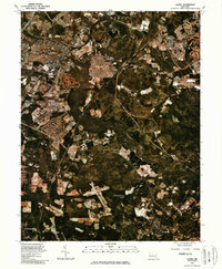
1981 Map of Laurel
USGS Topo · Published 1986About this map
The Patuxent River corridor and its surrounding developing landscapes define this 1981 orthophotoquad. This aerial-derived perspective highlights the suburban growth of Laurel and Maryland City along the critical transport axis of the Baltimore Washington Parkway. The imagery captures the transition of the Maryland countryside into a more densely populated suburban hub, while preserving large swaths of forested terrain and water features like the Rocky Gorge Reservoir to the northwest. To the south, the map reaches toward Greenbelt and Bowie, showing the extent of land clearing and residential patterning typical of the early 1980s. Natural hydrological features such as the Little Patuxent River, Cash Lake, and Redington Lake provide a stark contrast to the expanding infrastructure and housing developments that were rapidly reshaping the Prince George's County landscape during this era.
Find a feature on this map
10 named features on this map. Tap any name to fly to it.
Don’t see what you’re looking for? This feature index may not catch every label — zoom into the map to look around manually.
Map Details
Editions of this 1981 Laurel Map
This is the sole edition of this map. No revisions or reprints were ever made.
Other maps of this area

1892 · Laurel
USGS Topo · 1:62,500

1892 · Owensville
USGS Topo · 1:62,500

1894 · Laurel
USGS Topo · 1:62,500

1894 · Relay
USGS Topo · 1:62,500

1895 · Owensville
USGS Topo · 1:62,500

1897 · Laurel
USGS Topo · 1:62,500

1899 · Patuxent
USGS Topo · 1:125,000

1900 · Washington
USGS Topo · 1:62,500

1905 · Owensville
USGS Topo · 1:62,500

1906 · Patuxent
USGS Topo · 1:125,000