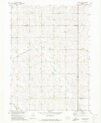
1971 Map of Laurel SE
USGS Topo · Published 1973About this map
The rolling agricultural uplands of northeast Nebraska are documented here at the start of the 1970s, specifically where the borders of Wayne, Dixon, and Cedar counties converge. The rural landscape is punctuated by the remnants of earlier settlement patterns, most notably an Old RR Grade running parallel to Deer Creek in the southwest. Educational life in the township is still anchored by traditional sites like Flag Sch, Sunny Slope Sch, and Pleasant Valley Sch, along with the numerically designated School No 15. At the southern edge of the sheet, the city of Wayne begins to appear, featuring a local Golf Course and modern utility markers like a Radio Tower. The drainage system for these farmlands is clearly defined by several small waterways including Dog Creek, Baker Cr, and Dry Creek, while Mount Hope Cemetery provides a specific point of interest for genealogical research in this tri-county area.
Find a feature on this map
16 named features on this map. Tap any name to fly to it.
Don’t see what you’re looking for? This feature index may not catch every label — zoom into the map to look around manually.
Map Details
Editions of this 1971 Laurel SE Map
This is the sole edition of this map. No revisions or reprints were ever made.
Other maps of this area

1955 · Sioux City
USGS Topo · 1:250,000

1958 · Sioux City
USGS Topo · 1:250,000

1959 · Sioux City
USGS Topo · 1:250,000

1963 · Winside
USGS Topo · 1:24,000

1963 · Wayne
USGS Topo · 1:24,000

1966 · Altona NW
USGS Topo · 1:24,000

1967 · Wakefield SW
USGS Topo · 1:24,000
1967 · Concord
USGS Topo · 1:24,000
1971 · Laurel
USGS Topo · 1:24,000

1971 · Belden
USGS Topo · 1:24,000