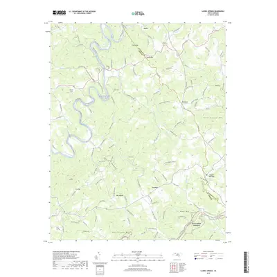
2019 Map of Laurel Springs
USGS Topo · Published 2019About this map
Ore Knob and the surrounding high country of the Blue Ridge define this landscape at the border of Ashe and Alleghany Counties. The South Fork New River carves a winding path through the northwest, designated here as a New Wild and Scenic River, while the southern reaches are dominated by the elevation of Upper Mtn and Rattlesnake Mtn. The transport network is anchored by the Blue Ridge Parkway tracing the southern ridges, contrasting with the dense web of named mountain roads like Scrape Bottom Rd and Huckleberry Ridge Rd. Small settlements such as Laurel Springs, Transou, and Scottville serve as local hubs, connected by a topography of deep drainages including Cranberry Creek and Prathers Cr. Genealogists will find interest in localized burial grounds like the Matt Carson Cem and New Hope Cem, which mark long-established family ties to these hills.
Find a feature on this map
124 named features on this map. Tap any name to fly to it.
Don’t see what you’re looking for? This feature index may not catch every label — zoom into the map to look around manually.
Map Details
Editions of this 2019 Laurel Springs Map
This is the sole edition of this map. No revisions or reprints were ever made.
Other maps of this area

1889 · Wytheville
USGS Topo · 1:125,000

1889 · Wilkesboro
USGS Topo · 1:125,000

1891 · Wilkesboro
USGS Topo · 1:125,000

1892 · Wytheville
USGS Topo · 1:125,000

1930 · Independence
USGS Topo · 1:48,000

1933 · Independence
USGS Topo · 1:62,500

1935 · Mouth of Wilson
USGS Topo · 1:48,000

1940 · Mouth of Wilson
USGS Topo · 1:62,500

1953 · Winston-Salem
USGS Topo · 1:250,000

1955 · Winston-Salem
USGS Topo · 1:250,000