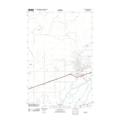
2011 Map of Laurel
USGS Topo · Published 2011About this map
Yellowstone River and the Clarks Fork Yellowstone River converge in this corner of Montana, anchoring the rail-and-agriculture hub of Laurel. The town's grid is dominated by the massive BNSF Railway presence, reflecting its longstanding identity as a critical junction point. To the west, the smaller settlement of Spurling sits along the tracks, while irrigation features like the Italian Ditch, Big Ditch, and Clarks Fork Ditch illustrate the complex water management required for the surrounding valley farms. North of the city, the landscape shifts from the developed streets of the city center to the wide expanse of Clappers Flat and the drainage of Dry Creek. Industrial and municipal landmarks, including the Cenex Harvest State Fire Brigade and the Laurel Municipal Airport, highlight the modern utility of the corridor between the river and the northern gulches like Red and King Gulch.
Find a feature on this map
96 named features on this map. Tap any name to fly to it.
Don’t see what you’re looking for? This feature index may not catch every label — zoom into the map to look around manually.
Map Details
Editions of this 2011 Laurel Map
This is the sole edition of this map. No revisions or reprints were ever made.
Other maps of this area

1954 · Billings
USGS Topo · 1:250,000

1956 · Molt
USGS Topo · 1:24,000

1956 · Rimrock
USGS Topo · 1:24,000

1956 · Silesia
USGS Topo · 1:24,000

1956 · Two Pine School
USGS Topo · 1:24,000

1956 · Laurel
USGS Topo · 1:24,000

1956 · Park City
USGS Topo · 1:24,000
1956 · Montaqua
USGS Topo · 1:24,000

1956 · Mossmain
USGS Topo · 1:24,000

1957 · Billings
USGS Topo · 1:250,000