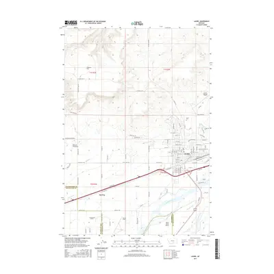
2017 Map of Laurel
USGS Topo · Published 2017About this map
The city of Laurel serves as a significant regional hub where the Yellowstone River and Clarks Fork Yellowstone River converge, shaping the agricultural and industrial character of the valley. A complex network of irrigation infrastructure, including the Big Ditch, Mason Canal, and Italian Ditch, underscores the area's long-standing reliance on water management for ranching and farming. North of the city, the terrain rises toward Clappers Flat and the drainage of Dry Cr, while the southwestern reaches are marked by the White Horse Bench. Aviation plays a notable role in the local landscape, with three distinct facilities present: the Laurel Municipal Airport, Cottonwood Airport, and Fly WM Airport. Transport routes like Old US Hwy 10 W and the E B N RD rail corridor further illustrate the town's position as a crossroads between Yellowstone and Stillwater counties.
Find a feature on this map
94 named features on this map. Tap any name to fly to it.
Don’t see what you’re looking for? This feature index may not catch every label — zoom into the map to look around manually.
Map Details
Editions of this 2017 Laurel Map
This is the sole edition of this map. No revisions or reprints were ever made.
Other maps of this area

1954 · Billings
USGS Topo · 1:250,000

1956 · Molt
USGS Topo · 1:24,000

1956 · Rimrock
USGS Topo · 1:24,000

1956 · Silesia
USGS Topo · 1:24,000

1956 · Two Pine School
USGS Topo · 1:24,000

1956 · Laurel
USGS Topo · 1:24,000

1956 · Park City
USGS Topo · 1:24,000
1956 · Montaqua
USGS Topo · 1:24,000

1956 · Mossmain
USGS Topo · 1:24,000

1957 · Billings
USGS Topo · 1:250,000