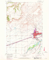
1969 Map of Laurel
USGS Topo · Published 1970About this map
The Yellowstone River and Clarks Fork Yellowstone River converge at the southeastern corner of this survey, defining a landscape dominated by the industrial and agricultural infrastructure of Laurel. The town's significance as a transportation and processing hub is evident in the dense network of Burlington Northern rail lines and the presence of a large Oil Refinery. To the west, the arid terrain of Clappers Flat gives way to a complex irrigation system, featuring numerous man-made waterways like Big Ditch and Italian and Clark Fork Canyon Ditch, which were essential for transforming the river valley into productive farmland. Within the expanding urban footprint of Laurel, community life is anchored by centers such as St Anthonys Ch, St Johns Ch, and several neighborhood schools including West Grade Sch and South Grade Sch.
Find a feature on this map
38 named features on this map. Tap any name to fly to it.
Don’t see what you’re looking for? This feature index may not catch every label — zoom into the map to look around manually.
Map Details
Editions of this 1969 Laurel Map
This is the sole edition of this map. No revisions or reprints were ever made.
Other maps of this area

1954 · Billings
USGS Topo · 1:250,000

1956 · Molt
USGS Topo · 1:24,000

1956 · Rimrock
USGS Topo · 1:24,000

1956 · Silesia
USGS Topo · 1:24,000

1956 · Two Pine School
USGS Topo · 1:24,000

1956 · Laurel
USGS Topo · 1:24,000

1956 · Park City
USGS Topo · 1:24,000
1956 · Montaqua
USGS Topo · 1:24,000

1956 · Mossmain
USGS Topo · 1:24,000

1957 · Billings
USGS Topo · 1:250,000