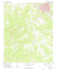
1971 Map of Laurens South
USGS Topo · Published 1975About this map
The city of Laurens serves as the central hub of this South Carolina landscape, with the historic Courthouse and Library anchoring the urban core. To the south, the terrain transitions into a patchwork of rural homesteads and agricultural tracts, tied together by the Seaboard Coast Line railroad. Small rural junctions and communities like Maddens and Cold Point appear along the rail corridor and primary roadways, illustrating the 1970s Piedmont settlement pattern.
Find a feature on this map
39 named features on this map. Tap any name to fly to it.
Don’t see what you’re looking for? This feature index may not catch every label — zoom into the map to look around manually.
Map Details
Editions of this 1971 Laurens South Map
This is the sole edition of this map. No revisions or reprints were ever made.
Other maps of this area

1892 · Abbeville
USGS Topo · 1:125,000

1941 · Spartanburg
USGS Topo · 1:250,000

1953 · Spartanburg
USGS Topo · 1:250,000

1954 · Greenville
USGS Topo · 1:250,000

1957 · Fountain Inn
USGS Topo · 1:62,500

1958 · Greenville
USGS Topo · 1:250,000

1960 · Spartanburg
USGS Topo · 1:250,000

1963 · Spartanburg
USGS Topo · 1:250,000

1964 · Spartanburg
USGS Topo · 1:250,000

1969 · Ora
USGS Topo · 1:24,000