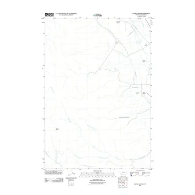
2011 Map of Laurin Canyon
USGS Topo · Published 2011About this map
The Ruby Range anchors the western side of this Montana landscape, where the terrain transitions from high slopes into a complex network of water management and natural drainages. Agricultural infrastructure is a defining characteristic of the valley floor, evidenced by the Ayotte Ditch, Passamari Ditch, and the West Bench Canal, which draw from the Ruby River to support the surrounding lands. Notable topographic features include the prominent Laurin Canyon and Robinson Canyon in the north, while the southern reaches are defined by the various branches of Hinch Creek and the secluded Waruhoop Springs. This survey illustrates the intricate relationship between the natural flow of the Ruby River and the engineered irrigation systems necessary for high-plains ranching and farming in Madison County during the early 21st century.
Find a feature on this map
25 named features on this map. Tap any name to fly to it.
Don’t see what you’re looking for? This feature index may not catch every label — zoom into the map to look around manually.
Map Details
Editions of this 2011 Laurin Canyon Map
This is the sole edition of this map. No revisions or reprints were ever made.
Other maps of this area

1893 · Dillon
USGS Topo · 1:250,000

1955 · Dillon
USGS Topo · 1:250,000

1957 · Dillon
USGS Topo · 1:250,000

1958 · Dillon
USGS Topo · 1:250,000

1961 · Mine Gulch
USGS Topo · 1:24,000

1961 · Beaverhead Rock SE
USGS Topo · 1:24,000

1962 · Dillon
USGS Topo · 1:250,000
1962 · Beaverhead Rock NE
USGS Topo · 1:24,000
1963 · Sheridan
USGS Topo · 1:24,000
1963 · Metzel Ranch
USGS Topo · 1:24,000