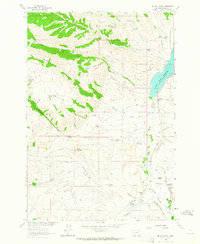
1963 Map of Metzel Ranch
USGS Topo · Published 1964About this map
The Ruby River corridor in Madison County defines this landscape, where the Ruby River Reservoir meets a network of ranching homesteads and historic irrigation works. This 1963 survey captures a specific era of high-country agriculture, documenting family landmarks such as the Metzel Ranch, Maloney Ranch, and several established homesites like the Burdick Place and Ball Place. The presence of the Upper Ruby Cem near Jack Creek offers a touchstone for genealogists tracing the early settlers of this valley.
Find a feature on this map
45 named features on this map. Tap any name to fly to it.
Don’t see what you’re looking for? This feature index may not catch every label — zoom into the map to look around manually.
Map Details
Editions of this 1963 Metzel Ranch Map
2 editions found
Other maps of this area

1893 · Dillon
USGS Topo · 1:250,000

1955 · Dillon
USGS Topo · 1:250,000

1957 · Dillon
USGS Topo · 1:250,000

1958 · Dillon
USGS Topo · 1:250,000

1961 · Mine Gulch
USGS Topo · 1:24,000

1961 · Red Canyon
USGS Topo · 1:24,000

1961 · Beaverhead Rock SE
USGS Topo · 1:24,000

1962 · Dillon
USGS Topo · 1:250,000
1963 · Home Park Ranch
USGS Topo · 1:24,000
1963 · Laurin Canyon
USGS Topo · 1:24,000