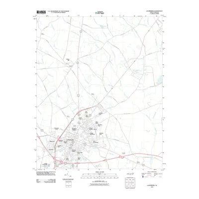
2010 Map of Laurinburg
USGS Topo · Published 2010About this map
Laurinburg and its surrounding neighborhoods anchor this 2010 survey of southern North Carolina, where a dense network of suburban developments like Westland Forest, Middleton Heights, and McLaurin Acres meet the rural expanses of Scotland County. The town's historical geography is punctuated by numerous family and community burial grounds, including the Hillside Cemetery and Leach Cemetery, which provide significant data points for genealogists. The landscape is defined by the winding paths of Leith Creek and Jordan Creek, which drain the low-lying agricultural and residential areas. To the north, Gibson Mill and several smaller enclaves like Tara Acres and Glynn Fields show the expansion of the community toward the headwaters of Little Juniper Creek. The persistence of historically named routes such as Old Wire Rd and Old Lumberton Rd reflects the long-standing transportation corridors that have shaped the region's development from its agrarian roots into a modern regional hub.
Find a feature on this map
75 named features on this map. Tap any name to fly to it.
Don’t see what you’re looking for? This feature index may not catch every label — zoom into the map to look around manually.
Map Details
Editions of this 2010 Laurinburg Map
This is the sole edition of this map. No revisions or reprints were ever made.
Other maps of this area

1942 · Rockingham
USGS Topo · 1:125,000

1949 · Gibson
USGS Topo · 1:24,000

1949 · Wagram
USGS Topo · 1:24,000

1949 · Laurinburg
USGS Topo · 1:24,000

1949 · Silver Hill
USGS Topo · 1:24,000

1949 · Marston
USGS Topo · 1:24,000

1949 · Wakulla
USGS Topo · 1:24,000

1949 · Hamlet
USGS Topo · 1:62,500

1949 · Laurinburg
USGS Topo · 1:62,500

1953 · Florence
USGS Topo · 1:250,000
Featured Places
- Laurinburg, NC
- East Laurinburg, NC
- Langley Place Mobile Home Park, NC
- McBryde Farm, NC
- Norman Heights, Laurinburg