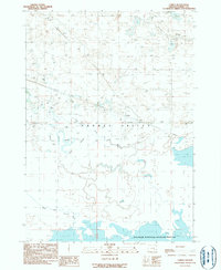
1990 Map of Lawen
USGS Topo · Published 1990About this map
Lawen serves as the central settlement in this expansive section of the Harney Valley, where complex water management systems define the high desert basin. The hydrologic character of the landscape is dominated by the splitting of the East Fork Silvies River and West Fork Silvies River, which feed into an intricate network of waterways including Ninemile Slough, Black Slough, and Square Well Slough. These natural and modified channels illustrate the critical importance of water distribution for both ranching and conservation in the late 20th century. A significant portion of the southern landscape is occupied by the Malheur National Wildlife Refuge, highlighting the region's role as a vital sanctuary within the Great Basin drainage. The numerous levees and check dams printed across the map indicate the historical efforts to control seasonal runoff within this sensitive riparian ecosystem.
Find a feature on this map
9 named features on this map. Tap any name to fly to it.
Don’t see what you’re looking for? This feature index may not catch every label — zoom into the map to look around manually.
Map Details
Editions of this 1990 Lawen Map
This is the sole edition of this map. No revisions or reprints were ever made.
Other maps of this area

1955 · Burns
USGS Topo · 1:250,000

1958 · Burns
USGS Topo · 1:250,000

1959 · Burns
USGS Topo · 1:250,000

1959 · Harney
USGS Topo · 1:62,500

1959 · Lawen
USGS Topo · 1:62,500

1960 · Crane
USGS Topo · 1:62,500

1973 · Carson Point
USGS Topo · 1:24,000

1978 · Malheur Lake
USGS Topo · 1:100,000

1978 · Stinkingwater Mountains
USGS Topo · 1:100,000
1990 · Ninemile Slough
USGS Topo · 1:24,000