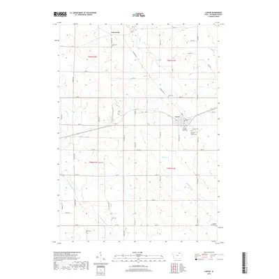
2018 Map of Lawler
USGS Topo · Published 2018About this map
Lawler and the small crossroads community of Jacksonville anchor this section of Chickasaw County, where the agricultural grid is defined by a dense network of local roads and family-named routes. The landscape is characterized by the winding path of the E Fork Wapsipinicon River and its tributaries, including Simpson Cr and Plum Cr, which bisect the surveyed sections of t96n r11w and t95n r12w. The distribution of cemeteries across the township reflects a history of multi-denominational settlement, with sites such as Our Lady of Mount Carmel Cem, Lutheran Cem, and Saint Johns Germán Lutheran Cem concentrated near the Lawler town site. Further north and west, smaller burial grounds like Jacksonville Cem, Union Cem, and Boyd Cem mark the heritage of rural homesteads located along thoroughfares like Ridgeway Blvd and Quinlan Ave.
Find a feature on this map
46 named features on this map. Tap any name to fly to it.
Don’t see what you’re looking for? This feature index may not catch every label — zoom into the map to look around manually.
Map Details
Editions of this 2018 Lawler Map
This is the sole edition of this map. No revisions or reprints were ever made.
Other maps of this area

1954 · Mason City
USGS Topo · 1:250,000

1954 · Waterloo
USGS Topo · 1:250,000

1955 · Waterloo
USGS Topo · 1:250,000

1957 · Mason City
USGS Topo · 1:250,000

1958 · Mason City
USGS Topo · 1:250,000

1971 · Alpha
USGS Topo · 1:24,000

1971 · Fredericksburg
USGS Topo · 1:24,000

1971 · Frederika
USGS Topo · 1:24,000

1972 · Jerico
USGS Topo · 1:24,000
1972 · New Hampton
USGS Topo · 1:24,000