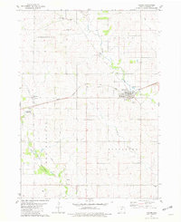
1981 Map of Lawler
USGS Topo · Published 1982About this map
Lawler serves as a central hub in Chickasaw County, where the Chicago Milwaukee St Paul and Pacific railroad bisects the township landscape. The area is defined by a dense network of small family and community burial grounds, including Jacksonville Cem, Lutheran Cem, North Cem, and the remote Boyd Cem near the southern boundary. These sites, often located near small clusters like Jacksonville and Bennett, suggest the deep roots of early settlement in the Stapleton and Utica regions.
Find a feature on this map
28 named features on this map. Tap any name to fly to it.
Don’t see what you’re looking for? This feature index may not catch every label — zoom into the map to look around manually.
Map Details
Editions of this 1981 Lawler Map
This is the sole edition of this map. No revisions or reprints were ever made.
Other maps of this area

1954 · Mason City
USGS Topo · 1:250,000

1954 · Waterloo
USGS Topo · 1:250,000

1955 · Waterloo
USGS Topo · 1:250,000

1957 · Mason City
USGS Topo · 1:250,000

1958 · Mason City
USGS Topo · 1:250,000

1971 · Alpha
USGS Topo · 1:24,000

1971 · Fredericksburg
USGS Topo · 1:24,000

1971 · Frederika
USGS Topo · 1:24,000

1972 · Jerico
USGS Topo · 1:24,000
1972 · New Hampton
USGS Topo · 1:24,000