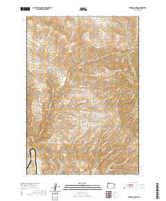
2020 Map of Lawrence Creek
USGS Topo · Published 2020About this map
Iron Mtn rises above the drainages of eastern Baker County, anchoring a landscape shaped by water management and mineral potential. The intricate network of seasonal flows and springs, such as Iron Mountain Spring, Orman Spring, and Devils Spring, underscores the critical importance of water in this high-desert environment. Strategic water improvements like Welch Reservoir, Taylor Reservoir, and Bedsprings Flat Reservoir illustrate the area's pastoral and ranching legacy, while the presence of Taylor Ditch suggests a history of diverted resources to support local land use.
Find a feature on this map
40 named features on this map. Tap any name to fly to it.
Don’t see what you’re looking for? This feature index may not catch every label — zoom into the map to look around manually.
Map Details
Editions of this 2020 Lawrence Creek Map
This is the sole edition of this map. No revisions or reprints were ever made.
Other maps of this area

1901 · Baker City
USGS Topo · 1:125,000

1915 · Pine
USGS Topo · 1:125,000

1955 · Baker
USGS Topo · 1:250,000

1957 · Sparta
USGS Topo · 1:62,500

1957 · Durkee
USGS Topo · 1:62,500

1959 · Baker
USGS Topo · 1:250,000
1967 · Keating
USGS Topo · 1:24,000

1967 · Lost Basin
USGS Topo · 1:24,000

1981 · Baker
USGS Topo · 1:100,000
1987 · Oxman
USGS Topo · 1:24,000