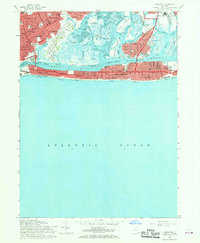
1966 Map of Lawrence
USGS Topo · Published 1968About this map
The barrier islands and South Shore marshes of western Nassau County are captured here in the mid-1960s, showing a densely developed coastal landscape defined by inlets and intricate tidal channels. Long Beach and Atlantic Beach dominate the oceanfront, connected to the mainland by the Atlantic Beach Bridge. Inland, the established residential grids of Cedarhurst, Lawrence, and Inwood are woven between recreational landmarks like the Rockaway Hunt Club and the Keystone Yacht Club.
Find a feature on this map
83 named features on this map. Tap any name to fly to it.
Don’t see what you’re looking for? This feature index may not catch every label — zoom into the map to look around manually.
Map Details
Editions of this 1966 Lawrence Map
3 editions found
Other maps of this area

1889 · Brooklyn
USGS Topo · 1:62,500

1891 · Brooklyn
USGS Topo · 1:62,500

1897 · Brooklyn
USGS Topo · 1:62,500

1897 · Hempstead
USGS Topo · 1:62,500

1898 · Hempstead
USGS Topo · 1:62,500

1898 · Brooklyn
USGS Topo · 1:62,500

1899 · Hempstead
USGS Topo · 1:62,500

1900 · Brooklyn
USGS Topo · 1:62,500

1903 · Hempstead
USGS Topo · 1:62,500
1947 · Jamaica
USGS Topo · 1:24,000