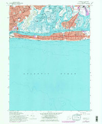
1966 Map of Lawrence
USGS Topo · Published 1979About this map
The coastal communities of Nassau County are presented in detail during the late 1960s, showing a landscape defined by complex tidal waterways and dense suburban development. The Long Island rail line connects the established centers of Cedarhurst, Inwood, and Lawrence, while the barrier islands feature the grid-work of Long Beach and Atlantic Beach. Along the marshy interface of Reynolds Channel, numerous tidal flats and named marshes like North Green Sedge and South Green Sedge persist alongside modern infrastructure. Notable local landmarks for researchers include St Marys Cem, the Rockaway Hunt Club, and Temple Israel. This document captures the shoreline prior to later revisions, documenting the extensive network of schools such as Sch No 2 and the emerging industrial presence of the Powerplant and Incinerator near Island Park.
Find a feature on this map
92 named features on this map. Tap any name to fly to it.
Don’t see what you’re looking for? This feature index may not catch every label — zoom into the map to look around manually.
Map Details
Editions of this 1966 Lawrence Map
3 editions found
Other maps of this area

1889 · Brooklyn
USGS Topo · 1:62,500

1891 · Brooklyn
USGS Topo · 1:62,500

1897 · Brooklyn
USGS Topo · 1:62,500

1897 · Hempstead
USGS Topo · 1:62,500

1898 · Hempstead
USGS Topo · 1:62,500

1898 · Brooklyn
USGS Topo · 1:62,500

1899 · Hempstead
USGS Topo · 1:62,500

1900 · Brooklyn
USGS Topo · 1:62,500

1903 · Hempstead
USGS Topo · 1:62,500
1947 · Jamaica
USGS Topo · 1:24,000