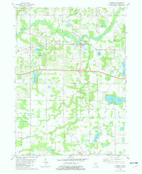
1981 Map of Lawrence
USGS Topo · Published 1982About this map
Lawrence serves as the focal point of this Van Buren County landscape, situated along the winding course of the Paw Paw River. The village's geographic character is defined by the Chesapeake and Ohio railroad corridor and the Red Arrow Highway, which trace the local transportation history of southwestern Michigan. To the south, a dense network of water bodies including Shafer Lake, Christie Lake, and Pond Lily Lake suggests a region historically tied to lakeside settlement and seasonal recreation.
Find a feature on this map
34 named features on this map. Tap any name to fly to it.
Don’t see what you’re looking for? This feature index may not catch every label — zoom into the map to look around manually.
Map Details
Editions of this 1981 Lawrence Map
This is the sole edition of this map. No revisions or reprints were ever made.
Other maps of this area

1927 · Hartford
USGS Topo · 1:62,500

1927 · Bangor
USGS Topo · 1:62,500

1931 · Bangor
USGS Topo · 1:62,500

1931 · Hartford
USGS Topo · 1:62,500

1943 · Bangor
USGS Topo · 1:62,500

1944 · Marcellus
USGS Topo · 1:62,500

1946 · Marcellus
USGS Topo · 1:62,500

1946 · Gobles
USGS Topo · 1:62,500

1948 · Gobles
USGS Topo · 1:62,500

1949 · Gobles
USGS Topo · 1:62,500