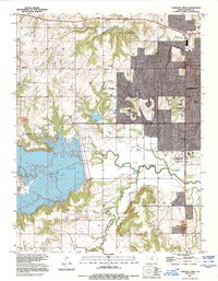
1991 Map of Lawrence West
USGS Topo · Published 1995About this map
The western expansion of Lawrence dominates the eastern half of this landscape, where the University of Kansas and its West Campus stand as major regional landmarks. To the west, the massive impoundment of Clinton Lake has reshaped the valley, bordered by the recreational grounds of Clinton State Park. The map documents a blend of academic growth, suburban infrastructure, and rural remnants, including the small settlement of Kanwaka and the Richland Cem near the southern border.
Find a feature on this map
24 named features on this map. Tap any name to fly to it.
Don’t see what you’re looking for? This feature index may not catch every label — zoom into the map to look around manually.
Map Details
Editions of this 1991 Lawrence West Map
This is the sole edition of this map. No revisions or reprints were ever made.
Other maps of this area

1885 · Lawrence
USGS Topo · 1:125,000

1886 · Oskaloosa
USGS Topo · 1:125,000

1888 · Oskaloosa
USGS Topo · 1:125,000

1889 · Lawrence
USGS Topo · 1:125,000

1894 · Oskaloosa
USGS Topo · 1:125,000

1947 · Lawrence
USGS Topo · 1:250,000

1949 · Williamstown
USGS Topo · 1:24,000

1949 · Perry
USGS Topo · 1:24,000

1950 · Perry
USGS Topo · 1:24,000

1950 · Kansas City
USGS Topo · 1:250,000