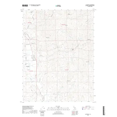
2018 Map of Laytonville
USGS Topo · Published 2018About this map
Laytonville serves as the central hub of this Northern California landscape, where the valley floor meets the rising peaks of the Coast Range. The settlement is anchored by the historic Laytonville Cem and a network of local roads such as Branscomb Rd and Dos Rios Rd that branch out toward the surrounding heights. The terrain is defined by prominent elevations like Woodman Peak and Farley Peak, which overlook a complex drainage system including the waters of Tenmile Cr and Cahto Cr. High-altitude features such as Farley Lake and Twin Lakes suggest a landscape shaped by seasonal hydrology and significant relief. To the east, the winding Laytonville Dos Rios Rd climbs through Bear Pen Canyon toward Windy Point, illustrating the transition from the settled valley floor to the remote ridge country of Mendocino County.
Find a feature on this map
57 named features on this map. Tap any name to fly to it.
Don’t see what you’re looking for? This feature index may not catch every label — zoom into the map to look around manually.
Map Details
Editions of this 2018 Laytonville Map
This is the sole edition of this map. No revisions or reprints were ever made.
Other maps of this area

1920 · Cummings
USGS Topo · 1:62,500

1920 · Covelo
USGS Topo · 1:62,500

1921 · Branscomb
USGS Topo · 1:62,500

1951 · Branscomb
USGS Topo · 1:62,500

1951 · Laytonville
USGS Topo · 1:62,500

1952 · Spyrock
USGS Topo · 1:62,500

1952 · Leggett
USGS Topo · 1:62,500

1957 · Ukiah
USGS Topo · 1:250,000

1960 · Ukiah
USGS Topo · 1:250,000
1966 · Longvale
USGS Topo · 1:24,000