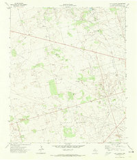
1971 Map of Lazy X Ranch
USGS Topo · Published 1974About this map
Lazy X Ranch sits at the heart of an intensive petroleum landscape in West Texas, as documented by this 1971 field check. The terrain is defined by a dense network of pipelines and service roads supporting multiple active production zones, including the Deep Rock Oil Field and the Furhman Mascho Oil Field. Unlike traditional agricultural maps, this survey reveals the industrial character of the Permian Basin, where family-named landmarks like the Lucky Strike Well and Triple Horn Well punctuate the arid plains. Water resources are scarce, represented primarily by cattle tanks such as North Hackberry Tank and Little Hackberry Tank. The detailed mapping of the Block 13 Oil Field and Andrews North Oil Field provides a technical record of mid-century energy development, showing the precise location of individual pump jacks and storage infrastructure across the ranch lands.
Find a feature on this map
20 named features on this map. Tap any name to fly to it.
Don’t see what you’re looking for? This feature index may not catch every label — zoom into the map to look around manually.
Map Details
Editions of this 1971 Lazy X Ranch Map
This is the sole edition of this map. No revisions or reprints were ever made.
Other maps of this area

1954 · Hobbs
USGS Topo · 1:250,000

1958 · Hobbs
USGS Topo · 1:250,000

1963 · Andrews
USGS Topo · 1:24,000

1968 · North Cowden NW
USGS Topo · 1:24,000

1968 · Clabber Hill Ranch
USGS Topo · 1:24,000

1971 · Florey
USGS Topo · 1:24,000

1971 · Frankel City
USGS Topo · 1:24,000

1971 · Whalen Lake
USGS Topo · 1:24,000

1971 · Sand Ranch
USGS Topo · 1:24,000

1971 · Shafter Lake
USGS Topo · 1:24,000