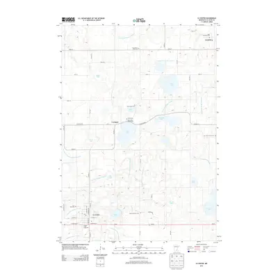
2013 Map of Le Center
USGS Topo · Published 2013About this map
Le Center serves as the focal point of this rural landscape, situated just north of MN-99 in a region defined by its dense network of lakes and managed water systems. The map reveals an intricate drainage pattern characterized by numerous named ditches, such as County Ditch Number Fortyfive and County Ditch Number Twentyone, which support the surrounding agricultural tracts. Small communities like Heidelberg and Lexington anchor the townships, while a high concentration of religious and historical sites, including Saint Scholastica Cem and Saint Marys Cem, provides a detailed record of local family heritage. The terrain is marked by significant water bodies like Clear Lake and School Lake, with the Le Sueur County Fairgrounds indicating a central hub for regional social life. This survey documents the intersection of natural glacial lakes and the human engineering required to maintain the productive land of Le Sueur County.
Find a feature on this map
65 named features on this map. Tap any name to fly to it.
Don’t see what you’re looking for? This feature index may not catch every label — zoom into the map to look around manually.
Map Details
Editions of this 2013 Le Center Map
This is the sole edition of this map. No revisions or reprints were ever made.
Other maps of this area

1953 · Saint Paul
USGS Topo · 1:250,000

1957 · Belle Plaine
USGS Topo · 1:62,500

1957 · New Prague
USGS Topo · 1:62,500

1959 · Saint Paul
USGS Topo · 1:250,000

1965 · Cleveland
USGS Topo · 1:24,000

1965 · St Thomas
USGS Topo · 1:24,000

1966 · Montgomery
USGS Topo · 1:24,000

1966 · Cordova
USGS Topo · 1:24,000

1966 · Le Center
USGS Topo · 1:24,000
1966 · Kilkenny
USGS Topo · 1:24,000