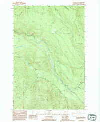
1987 Map of Le Dout Creek
USGS Topo · Published 1994About this map
The Puyallup River carves a deep valley through this corner of Pierce County, serving as the central drainage for a network of mountain streams including Le Dout Creek, Voight Creek, and Evans Creek. The topography is dominated by steep forested rises such as Cowling Ridge and the high elevations of The Divide to the south. Human activity in this mid-1980s landscape is primarily industrial and extractive, evidenced by numerous Barrow Pits and Gravel Pits scattered across the lower slopes. A Dam and a Gaging Station located along the river suggest active water management and monitoring during this era. The map also traces the path of a Flume following the river's course, a feature often associated with historical logging or hydroelectric operations in the Pacific Northwest.
Find a feature on this map
24 named features on this map. Tap any name to fly to it.
Don’t see what you’re looking for? This feature index may not catch every label — zoom into the map to look around manually.
Map Details
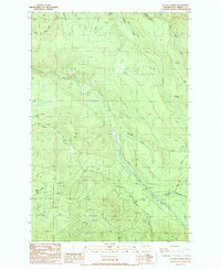
Editions of this 1987 Le Dout Creek Map
2 editions found
Other maps of this area

1897 · Tacoma
USGS Topo · 1:125,000

1900 · Tacoma
USGS Topo · 1:125,000

1913 · Cedar Lake
USGS Topo · 1:125,000

1924 · Mt Rainier
USGS Topo · 1:96,000

1928 · Mt Rainier
USGS Topo · 1:125,000

1937 · Eatonville
USGS Topo · 1:125,000

1942 · Lake Tapps
USGS Topo · 1:62,500

1944 · Lake Tapps
USGS Topo · 1:62,500

1950 · Yakima
USGS Topo · 1:250,000

1953 · Hoquiam
USGS Topo · 1:250,000